 |
|
| Classifieds I Travel I Exporters Listings I Importers I Trade Help I Business I Export ads I Publishing I RegisterBus I | |

Introducing the 2015 NEW AIR TECHNOLOGY
The latest UNMANNED AERIAL VEHICLES from Belarus Russia

APPLICATIONS AND DESIGN GUIDELINES
The demand on flying is old as humankind. As mankind has conquered the air and flying has been possible a path to unlimited revolutionary new application areas has been opened. These applications can be sorted in the following groups: transportation of person or goods, warfare, security and surveillance, scientific experiments and data acquisition. Traditionally these applications require manned aircrafts equipped by highly skilled pilots and staff. Therefore the operational and maintenance cost are still high despite of the fact that the cost of aircrafts and aerospace components are decreasing. As the technology and electronic computers advanced the requirement of cutting the cost of many of these applications created a new class of air systems, the unmanned aerial systems. Common characteristics of these systems that the operational costs are lower by a decade, operating does not require highly skilled pilots therefore these UAV systems are excellent choices for cost sensitive public applications which require professional solutions. In the following list some of our target applications can be read:
APPLICATIONS:
1/. A ir surveillance and photography
2/. Disaster monitoring (flood, forest fire or tsunami monitoring)
3/. security and defense (border control, area patrolling, monitoring industrial areas, oil and gas pipelines,
4/. electrical transmission lines, search for lost people, mass monitoring)
5/. archaeology
6/. agricultural applications (inland water monitoring, drought damage monitoring, pest infection monitoring)
7/. nature protection (animal movement monitoring, forest monitoring) Ak meteorological and climate research
There are many UAV solutions on the market in different scales and complexities. These can be classified from the viewpoint of effective range, system complexity, covered application area.
Our company targeted the development of a short‑range tactical UAV system with high system complexity and superior technical and functional capabilities. In the following list we summarize the main capabilities and design guidelines of UAV system:
Reliability:
This principle is the most important property of our system. We know that thereis no second chance in a UAV mission. A system failure is unacceptable atthese applications. Not only our reputation is jeopardized but even human life is endangered. Therefore all system components and software are designed for stable operation, long operating life and for harsh environmental conditions. We try to minimize the human factor in the system for reducing the risk of operator errors. The system has several emergency automatisms for the case of for example battery failure or communication jamming. The UAV can be autonomously operated but there is anytime the possibility of manual intervention when unforeseen circumstances occur. Therefore all UAV telemetry data (position, speed, height, battery charge, etc.) can be monitored real‑time.
Security:
It is important that no incompetent, unauthorized party can gain important mission data out of the system. Therefore all the communication and stored data is secured by authorization and encryption.
Fully automatic flight capability:
The system is capable to autonomously fly on a route of waypoint, placed over a map. The autopilot stabilizes the aircraft and navigates it on the flight route with the aid of GPS sensor. No manual intervention is needed under normal operating conditions.
Robust communication:
The usability of the system depends on the stable communication between the UAV and the ground monitoring station. In most cases the application requires real‑time data transmission from the aircraft at a high data rate, such as real‑time video streams. Our communication system is designed for long range, low latency and security. The communication is flexible and adaptive to always maximize the communication channel capacity. The modulation method is very robust and performs well in line‑of‑sight and non‑line‑of‑sight situations.
Own design:
The whole system, every key component and subsystem is designed by us or is fully under our control which fact provides us outstanding flexibility to user demands and requests and makes us independent from international market limitations.
Easy, user friendly operation:
All system component is straight‑forward, ergonomic, easy to operate and easy to replace or service.
Cost effective:
The system requires no infrastructure for operation. The operation requires nospecial skills, all necessary knowledge is provided during a short training. The maintenance costs are low, the aircrafts, sensors, other components are designed for long operating life.
Virsitile :
The system is flexible, supports different sensor and aircraft types and can be extended in the future. The aircraft is suitable to the most applications and can be equipped with even with user defined payload (with size, weight and power consumption limitation).
Effective range of 15 km Stabilized dual camera sensors: easily reconfigurable visible, color camera sensor and thermal camera sensor is offered with our system mounted on a gyro‑stabilized pan‑tilt pedestal. Color camera sensor has zoom feature and provide high resolution, color images. Thermal camera sensor is working in the 8‑12 um range and provides digital images with 16 bit thermal resolution.
Advanced image processing based object tracking is implemented in the on‑board Imaging system for fast and accurate target observation
Accurate, reliable MEMS sensors for inertial stabilization, speed and altitude measurement
Galileo‑ready GPS sensor for accurate navigation
For special request Glonass compatibility can also be provided. Support:
World‑wide support with quick reaction time is provided by us. We are open for unique requests and development as well.
In the following section the description of the system components will be presented.

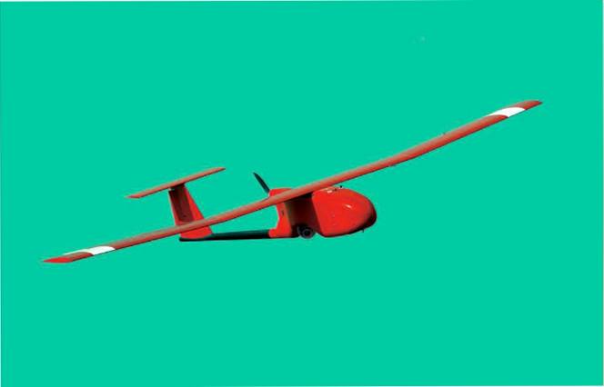
UAV system is a complete real‑time surveillance system with all the hardware and software components and support services which are required by the modern customers. The system has an air frame with BXAP15 aircraft which has an action radius more than 20 km with onboard autonomous navigation, high resolution video camera and video transmitter and recorder units. The BXGC10 ground control station with computers, antenna system and launch catapult is for real‑time control and monitor the BXAP15 airplanes, to aid the launch and recovery. The ground control station can be installed in the field or in a vehicle.
AIR‑FRAME
UAV system incorporates a high capacity, versatile, durable air platform which is carefully designed and developed specifically for unmanned surveillance purposes. It is small but powerful. Thanks to the careful aerodynamic design and composite technology UAV airplane has high endurance (up to 1.5 hour flight time), high payload capacity (3 kg of user defined payload) combined with the advantages of electrical propulsion.
It has a maintenance‑free brushless electrical engine for higher reliability, low noise emission and high power. It has a medium speed and altitude capability which makes it usable for wide range of applications. The energy storage element is the latest technology Lithium‑Polymer rechargeable battery with low weight, high capacity and long lifetime. Due to the high power propulsion it needs lower take‑off distance and can climb in a higher rate. The aerodynamic properties of BHE UAV grant excellent gliding capability and high stability under windy conditions. The hull is made of composite fiber and by default it has a low visibility gray color. If needed other colors are available.
It is small and easily transportable in a factory provided hard case. All necessary components are preinstalled on the aircraft. After unpacking only 5 major components have to be connected together by a simple "click" or by fixing a screw. Neither special tool, nor complex adjustment procedure are required. The process is so simple that one person can do it in 2 minutes.
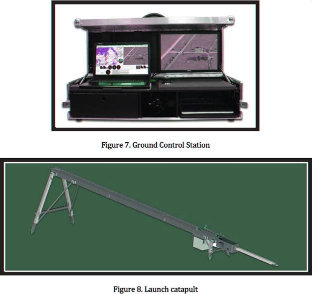
We provide a catapult which has electrical propulsion. The catapult can be installed on ground or on a vehicle. It can be transported in lm long pieces and can be assembled by fast connectors. Before take‑off the UAV airplane should be placed in the catapult. Before take‑off visual inspection of the system must be made by the user by the aid of a pre‑flight checklist. The system also executes self‑test procedures.
Take‑off can be initiated from software on the ground control station. During take‑off the UAV climbs with full engine power on a straight path until a safe altitude is reached. After completing the mission the landing procedure must be executed to recover the UAV. We do not use parachutes to recover the airplane, because this method eliminates all control over the aircraft. UAV lands by slipping on its belly on the ground and remains controllable during the whole landing procedure. This type of landing requires minimal ground preparations before landing, because no great pieces of ground objects should block the path of the airplane to protect the payload which is placed in the front of the airplane. At landing the wind direction is critical, because the speed of the aircraft must be kept as low as possible without stalling. Airplane stability can be maintained only if the airplane is landed against wind direction. The wind direction can change rapidly and the wind direction meter at the ground control station can not give precise information for landing. Therefore we have developed a fully autonomous landing system which uses radio transmitter beacons as direction guides. The on‑board system contains a microwave receiver which continuously measures the position of the aircraft in front of the landing place. On the landing place more radio transmitters are placed in a precise geometric arrangement. The radio signals are emitted such a way that the signals produce a virtual landing path which is followed by the autopilot. On the ground a fiber net is installed which captures the aircraft when it is approaching the ground.
PHYSICAL CHARACTERISTICS Air Speed: 50‑110 km/h
The speed range is carefully selected for general surveillance applications. The speed is referenced to the air medium and not to the ground. The speed over ground value (SOG) is influenced by wind direction and magnitude. Higher air speed can be reached during dipping, in that case 150 km/h is the maximal air speed.
Maximal Wind Magnitude: 40 km/h
To guarantee the aircraft stability in windy conditions it is advised not to fly in higher wind speeds.
Ceiling: min. 2000 m, depending on configuration
The ceiling value represents an altitude range referenced to the starting altitude level which grants optimal flying properties to the aircraft. Beyond this value the overall efficiency of the propulsion and the endurance may be degraded. Ceiling value mostly depends on the propeller because the air density decreases with altitude thus propeller blades with different higher pitch values needed for higher altitudes. The propeller can be changed by the user and makes it possible to fly at higher altitudes. The propeller mounted to the motor shaft determines the endurance, climbing rate, flight speed and altitude range, however it can be easily replaced by the user we suggest to use certified propellers otherwise we can not guarantee these parameters. Our certified propellers have high quality, matched to the aircraft and propulsion system and balanced perfectly for low noise output and low vibration.
Climbing rate: 2 m/s
The powerful electrical propulsion and the carefully selected propeller gives this capability to the UAV.
Wing Span: 3.7 m
The wing profile is carefully designed for good aerodynamic properties and provides superior gliding capability to the UAV and grants longer mission time by decreasing battery consumption. The wing is splitted in three pieces for easy transportation and can be easily assembled and mounted on the aircraft by screw.
Length: 1.7 m
This dimension provides good stability to the UAV. Because the body of the plane is made in one piece this is the largest dimension which determines the size of transportation hard case.
Payload capacity: 3 kg
User can place any payloads in the front of UAV. Payloads can be attached and detached easily by screws. Stable connection to the aircraft is guaranteed by uniform mechanical interface. The payloads and battery can be replaced in seconds. We provide some standard payloads such as high resolution visible light video camera and high resolution thermal camera.
Take‑off Weight: 17 kg
The low weight of the UAV makes it perfect for low speed cruising and surveillance. We provide catapult for take‑off aid.
Propulsion: electric brushless motor
Maintenance‑free, brushless, electric motor with internal cooling system grants reliability, high climbing rate, long endurance and long maintenance‑free period for the UAV. Low vibration compared to combustion engines provides low noise output and better video picture quality. The propeller mounted to the motor shaft determines the endurance, climbing rate, flight speed and altitude range, however it can be easily replaced by the user we suggest to use certified propellers otherwise we can not guarantee these parameters. Certified propellers have high quality, matched to the aircraft and propulsion system and balanced perfectly for low noise output and low vibration.
Battery: Lithium‑Polymer
Reliable, high capacity, low weight batteries gives the excellent endurance and climbing capabilities to UAV. These batteries can be easily replaced between missions for quick take‑ off. Although these batteries require less maintenance the health of the battery determines the aircraft performance. Therefore we provide a battery charger and conditioner unit with each UAV system to make it easier for the user to keep the batteries in good working order.
Endurance: up to 1.5 hour
The excellent propulsion system and aerodynamics of the UAV make this value possible. Endurance strongly depends on the battery type and health condition furthermore on flight route, wind conditions and mission altitude above the starting position. Often varying altitude during mission, higher wind speed or higher mission altitude require higher engine power and consume battery power decreasing mission time. UAV can provide this endurance time under most conditions but it cannot be guaranteed under any conditions.
AUTOPILOT
UAV autopilot is a microcontroller based autonomous navigation unit, which uses GPS for navigation and inertial sensor for stabilization. Our sensors are using modern MEMS technology, which yields small size, low weight, long operation time and high precision. Our autopilot, such the other components of BHE UAV system is designed for maximal reliability, precision and easy operability. Reliability is reached by using a dedicated ARM core microcontroller which does no other task only navigation, MEMS sensors which contain no conventional mechanical components and by careful software design which means that the software is tested even under extreme conditions and it can handle unexpected events. The GPS sensor has high sensitivity.
Main technical features:
32 bit ARM core processor: we have selected ARM core for our microcontroller, because it is the market leader industrial solution for microcontrollers, it is very stable and reliable
Galileo‑ready GPS module (4 Hz update rate): a high precision, high sensitivity receiver, which is capable to process the new European Galileo signals
3D inertial navigation sensor: MEMS sensor which is reliable and accurate under most extreme conditions and provides precise orientation information over the aircraft motion
MEMS pressure sensors: the accurate measurement of airspeed (by Pitot tube) and barometric altitude is also important for navigation and it is done by high quality, miniature pressure sensors
onboard flight data logging: every sensor data, output data, warnings, alarms, unsolicited events, command and telemetry data is logged onboard for security and user specific purposes
8 PWM servo output channel: these outputs give the control signals for the high precision, high torque servos which are connected to the airplane controls
General purpose digital control outputs: user specified digital control lines for special payloads
Main services:
Autonomous onboard navigation: our autopilot is able to stabilize and navigate the BHE UAV airplane on a defined route where the user specifies GPS coordinates and altitude over ground for each waypoints
No need for adjustments: every autopilot is adjusted to the BHE UAV in the factory, there is no need for the user to make any adjustments
On‑board pre‑flight self test: before flight the autopilot executes a test procedure and does not allow take‑off if major failure is detected in the system
Onboard logging: every sensor data, warnings, alarms, output signal, command and telemetry is logged by the autopilot for security and user post‑processing purposes
Flight route can be defined up to 500 waypoints: the memory of the microcontroller allows the handling of such high number of waypoints, between the waypoints the autopilot navigate the airplane on a straight line, complete flight route can be uploaded or downloaded from the ground control station
Real time route/flight parameter modification: the programmed waypoints can be modified during mission
Real time manual flight: some of the aircraft controls can be controlled manually, the operator can select which controls he wants to control and the aircraft will respond immediately, this function grants high degree of freedom over the capabilities of the aircraft, however it has the risk of loosing the aircraft due to manual failure
Preset flight maneuvers: in case of special flight events, such as loss of communication or an important sensor a predefined protocol will be executed by the autopilot to try to drive the aircraft back to the starting point
Health monitoring: the autopilot continuously evaluates the system performance, sensor data validity, sensor malfunction, communication link quality, unusual airplane motion, battery capacity, engine failure, etc and sends warning or alarm indications back to ground and stores these also on the onboard flash card
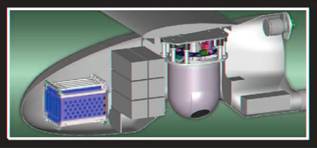
Figure 3. 3D CAD model of onboard electronics and sensors
ONBOARD DATA LOGGER
The UAV airborne system contains an on‑board data logger which receives video signals and other telemetry from onboard units and telecommand data from ground control, stores the video in high quality on flash disk.
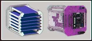
PAYLOADS
We provides two standard payloads for wide application areas. These payloads have a common mechanical interface which enables fast payload replacement. The battery is also can be replaced comfortably. These payloads have visible light or thermal cameras placed on an electromechanically stabilized gimbal system. It provides very stable video image in a wide range of situations, during different flight maneuvers.The camera payload has basic mechanical protection against impacts.
Visible Light Camera Payload, main technical specifications:
4k High resolution color camera: more than 520 TV line resolution
4k Optical zoom: 35x optical zoom is available
Autofocus: automatic and manual focusing mode is supported
Digital picture stabilization: electronically fine stabilization of the image is
made by onboard DSP processing
4k 25 frame per second
4k Automatic target tracking based on image processing
Thermal Camera Payload, main technical specifications:
4k 8‑12 um wavelength
uncooled microbolometer sensor
384x288 pixel resolution 4k 25 frame per second
4k 16 bit dynamic range
4k better than 100 mK thermal resolution
User Defined Payload:
Any kind of user defined equipment can be placed on the uniform mechanical interface. We supplies empty compartment for fitting any payload by the user. The weight of payload must be less than 3 kg. The proper weight balance of the aircraft must be maintained and the payload must not influence the aerodynamics of the aircraft.
COMMUNICATION
UAV system has adaptive, long range, reliable, robust wireless radio communication data link. The link operates on the C band (4.5‑4.9 GHz). The range is better than 5 kilometers and will be extended further. The data radios using highly interference tolerant spread spectrum modulation. Video is transmitted to ground on a high speed channel, command and telemetry is transmitted via lower speed but more robust channel. Robustness is also enhanced the error detection and correction coding. The radio link is adaptive so the radio parameters are depend on the distance between the aircraft and the ground control station. The communication is protected by additional scrambling for higher security.
GROUND CONTROL STATION
The UAV ground control station is a modular system which consist of a computer database server, one or more computer workstations, communication equipment with antennas and mast, GPS and wind sensors and the launch catapult. The database server and the workstation can be the same computer. The system can be mounted on a vehicle or it can be installed on ground. Every component can be disassembled for easier transportation. A transport hard case is provided for the system. The purpose of the ground control station is to provide all hardware elements for controlling the UAV, aid the take‑off and store every mission specific data. The real‑time control and monitor application runs on a workstation which can be placed far to the ground control station only a network connection must be set up between them. The database server stores every important data for further analysis. The user can replay the missions, search for a specific date and time. The data can be exported from the database. To provide a reliable and stable data link between the UAX aircraft the antennas are placed on a rotating mast.
The BHE UAV have to be inserted in the catapult and slipped into the guiding rails. An electrical motor accelerate the aircraft to the take‑off speed.
The ground control station has one or more computers, which are organized in a local area network. The heart of the system is the database server, which receives, processes and stores every pieces of information about the mission (telemetry data, command data, video streams, etc.). Furthermore the system contains the navigation client software, surveillance client software, server management software and other software utilities, which can run on the server computer or on separate workstations. The workstations are in connection with the server, by database query the actual data flow or a previously stored data flow can be retrieved from the server and it is displayed at the operator's workstation.
After powering on the server and booting is done the database server is operational and it connects to the communication equipment and via the data link discovers the UAV aircrafts within the action radius of the GCS.
To initiate a take‑off a navigator software should be started at the server or at a connected workstation. The navigator software requires identification of the operator what it is required for unambiguously determine the access rights. After successful identification the operator has the choice to start a new mission, join as observer to an existing mission, replay a previously recorded one or search for a specific date or location.
If he chooses a previously recorded mission the navigator client software queries the mission list and the operator can select which mission we would like to replay. Searching the archives will display a list of mission entry point with the specified initial date or location. Joining to an existing mission as observer allows the operator to get the route parameters, telemetry and video data, but cannot control the aircraft or affect anyhow the mission.
If the operator chooses to initiate a new mission the navigator client software asks whether the operator would like to plan a new mission route or load a previously saves mission route. By selecting the loading of previously saved mission the operator can review the mission and to start a take‑off he shall request the control of an aircraft. The navigator client software queries the server for the list of all aircrafts associated with the server. The list contains the operating status of the aircraft (online, on mission, offline, under repair, etc), which aircraft is within communication range, who controls the aircraft now, does the operator allowed to access and control the aircraft. If the control request is successful the operator have control over the aircraft and get all telemetry data. He can upload the mission route to the aircraft and the system verifies that the navigator client software route is identical to the one in the aircrafts memory. If the server indicates that the aircraft self‑test is passed the take‑off can be initiated. During mission the control over the aircraft is achieved via navigator client software, all the data is archived onboard and at the ground control station server, the camera payload control and visual observation is made with the surveillance client software.
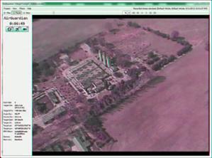
Figure 9. Screen layout of the current control software
Mission planning
A mission route can be created offline and can be modified online. A mission route contains all information for the UAV to be able to complete the mission fully automatically without need of manual supervision or control. The 3D coordinates of the starting point, the ending point and the middle waypoints must be defined, point‑by‑point or with the aid of the advances features of the navigator client software. Along the route the camera orientation can be defined for fully automatic visual observation applications. Special control functions can be associated with the waypoints (activating digital outputs, etc). Flight routes can be saved or loaded from the server.
Main functions of the navigator client software Mission planning:
4k Mission planning
4k 3D visualization of flight route (with zooming, rotation, panning) with map below the track
4k Handling of raster map or digital map
4k Handling of POIs, special areas (habited area, forbidden area, danger zone, state border, etc.)
4k Load, save mission routes Mission supervisioning:
4k Display of map, aircraft identifier, position, camera orientation and FOV, POIs for every available aircrafts (only one can be controlled)
4k Flight instruments (altitude, speed)
4k Aircraft alarm indications
Main functions of surveillance client software:
4k Control of aircraft camera (camera orientation, zoom, focus)
4k Camera information on OSD or separate text window (GPS coordinate, altitude, camera orientation, zoom level (FOV), etc)
Get coordinate (calculate the GPS coordinates of a designated point)
Hold coordinate (control the camera to hold the center of picture at the designated point)
‑i‑ Video display more video streams with adjustable time offset
Visual enhancements for each stream separately (brightness, contrast, intensity‑color map)
4k Zooming (in, out, defined area) Screenshot (whole picture, defined area)
4k Motion highlight (moving object is indicated, with movement vector and speed, trajectory line)
4k Motion tracking (a selected object/area can be tracked, send control information for the camera)
4k POI overlay on the map or video
Reporting feature (email sending with screenshot, operator comments)
CONCLUSIONS
The presented UAV system is under testing and is waiting for the final approval. Currently the UAV system operates with all major functions and the system parameters are continuously enhanced
BXAP15 UAV FEATURES
4‑ 3D CAD design
4‑ Composite construction
4‑ Easily transportable
4‑ Ease of assembly and operation
4‑ Recovery without special equipment 4‑ Realtime video stream downlink 4‑ Robust communication at C band 4‑ Onboard flight data logging 4‑ Catapult launch
4‑ Optionally retractable payload
SPECIFICATIONS
Speed: 60‑100 km/h
Ceiling: min. 3000 m depending on configuration
Wing span: 3.7 m
Length: 1.7 m
Take‑off weight: 17 kg
Endurance: up to 90 minutes
Propulsion: electric brushless
engine (1200W peak power)
Payload weight: up to 3 kg
GROUND CONTROL STATION
Whole system can be operated by the control station
4k Dual operator configuration (navigator and scout)
4k Additional operator
workstations can be connected to the control station via network interface
PAYLOAD
Default payload:
High resolution color camera head Gyro stabilized pan‑tilt platform
More than 35x optical zoom
Digital picture stabilization Optional: Thermal camera:
8‑12 mm range
384x288 pixel
16 bit digital data
Up to 25 fps
User defined: Other equipment up to 3 kg (net
weight)
SENSORS
Onboard Galileo‑ready GPS module
Accurate, high speed 3D inertial navigation sensor. MEMS pressure sensors for airspeed and barometric altitude measurement
These min gyro copters & UAV are now for sale. Please ask us for more details

 |
Read more about the ![]() [ Russian Gyro Commander & Hunter helicopters ]
[ Russian Gyro Commander & Hunter helicopters ]
MI26T Medical evac[ MI-26T ], firefighting [ MI-26T ], Cranes & heavy lift [ MI-26T ][ More pics of MI-26 for sale ]
[ NEW Mi-38 for 2016 orders ] [ NEW
SPECS 2015 Mi8-MSB Helicopter sales ![]() ] [ Production Line 2015 Mi8-MSB Helicopter ] [ Mi 2 2015 Mi2-MSB2 Helicopter for sale
] [ Production Line 2015 Mi8-MSB Helicopter ] [ Mi 2 2015 Mi2-MSB2 Helicopter for sale ![]() ]
]
[ NEW
Mi8-MSB Helicopter sales ![]() ] [ NEW
Helicopter sales ] [ MI-14 FIRE SERVICE helicopter for sale ] [ KA-32
Sales ] [ MI-8
sales ] [ MI-17 ] [ MI -17 Specs ] [ MI-171 Sales ]
[ MI-17 VIP
conversions ] [ Parts
& radio componants ] [ MI-24 ] [ MI-34 NEW Sales [ Antonov
An-124 CHARTER ] [ Pilot
& aircraft engineer job classifieds ] [ Jobs
available or wanted ] [ Leasing
helicopters ] [ Order
Sales Form ] [ Payment
terms ] [ LA8
Seaplanes ] [ Helicopter
parts free ads sell/buy ] [ Antonov
An-22 for sale ] ]We are now selling Helicopter spares from other branded Helicopters & Broker all types of helicopters for sale worldwide: Western Helicopter sales [ Western
AK1 helicopter ] [ CHINOOK 414 HELICOPTER SPARES ] [ BO-105 HELICOPTER SPARES ] email us today to have your helicopters listed [ West:
NZ stealth & rescue helicopter ]
] [ NEW
Helicopter sales ] [ MI-14 FIRE SERVICE helicopter for sale ] [ KA-32
Sales ] [ MI-8
sales ] [ MI-17 ] [ MI -17 Specs ] [ MI-171 Sales ]
[ MI-17 VIP
conversions ] [ Parts
& radio componants ] [ MI-24 ] [ MI-34 NEW Sales [ Antonov
An-124 CHARTER ] [ Pilot
& aircraft engineer job classifieds ] [ Jobs
available or wanted ] [ Leasing
helicopters ] [ Order
Sales Form ] [ Payment
terms ] [ LA8
Seaplanes ] [ Helicopter
parts free ads sell/buy ] [ Antonov
An-22 for sale ] ]We are now selling Helicopter spares from other branded Helicopters & Broker all types of helicopters for sale worldwide: Western Helicopter sales [ Western
AK1 helicopter ] [ CHINOOK 414 HELICOPTER SPARES ] [ BO-105 HELICOPTER SPARES ] email us today to have your helicopters listed [ West:
NZ stealth & rescue helicopter ]

|
EXPORTS IMPORTS & SHIPPING [ SHIPPING FORM ] [ Shipping Info ] [ Shipping & Freight ] [ Arriving Bangkok ] [ Importing to Thailand ] [ Importing Cars & Vehicles to Thailand ] [ Freight forwarding ] [ Container cost ] [ Sea freight ] [ Air freight ] [ Airlines in Thailand ] [Back to exporters list ] [ Container cost ] [ Shipping to USA ] [ Shipping Personal items ] [ Shipping Cars ] [ Shipping Agent ] [ Buddha images & Food ] [ Tariffs ] [ Letter of credit ] [ Fine Arts license ] [ SHIPPING FORM ]
COPYRIGHT: No
parts or parts of this website may be copied, printed or circulated for
publication in any form or part of without the express written permission of
Asia Trading Post Co Ltd. Please also note all Thailand affected pages which
include eg. law, immigration, visas can not be used unless written
permission is obtained from both 29 Tanin Co Ltd--Law Office & also Asia Trading
Post Co Ltd by way of contract. All infringements will be an infringement
of privacy and our company will act accordingly. See FAQs
|